The three landforms of North Carolina make up the three major geographic regions of the state: the Coastal Plain, the Piedmont, and the Mountains.
The Coastal Plain Region is usually divided into two sub regions: the Outer Coastal Plain, commonly referred to as the Tidewater; and the Inner Coastal, which is less impacted by the effects of the ocean as it is located further inward.
Coastal Plain Region
North Carolina's Coastal Plain is low, flat land along the Atlantic Ocean. It is often divided into two parts - the Outer Coastal Plain and the Inner Coastal Plain.
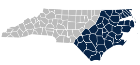
Coastal Plain Counties
Piedmont Region
North Carolina's Piedmont is the middle region of the state, located between the Coastal Plain and the Mountain regions. The name Piedmont comes from the Italian "pied" (foot) and "monte" (hill).
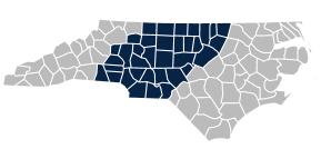
Piedmont Counties
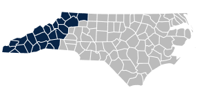
Mountain Region
North Carolina's Mountain region is in the western part of the state. It is smaller in area than the Piedmont and Coastal Plain. The elevation in this region reaches to more than one mile high.